Make virtual site visits with on-demand real-world views: Nearmap 3D
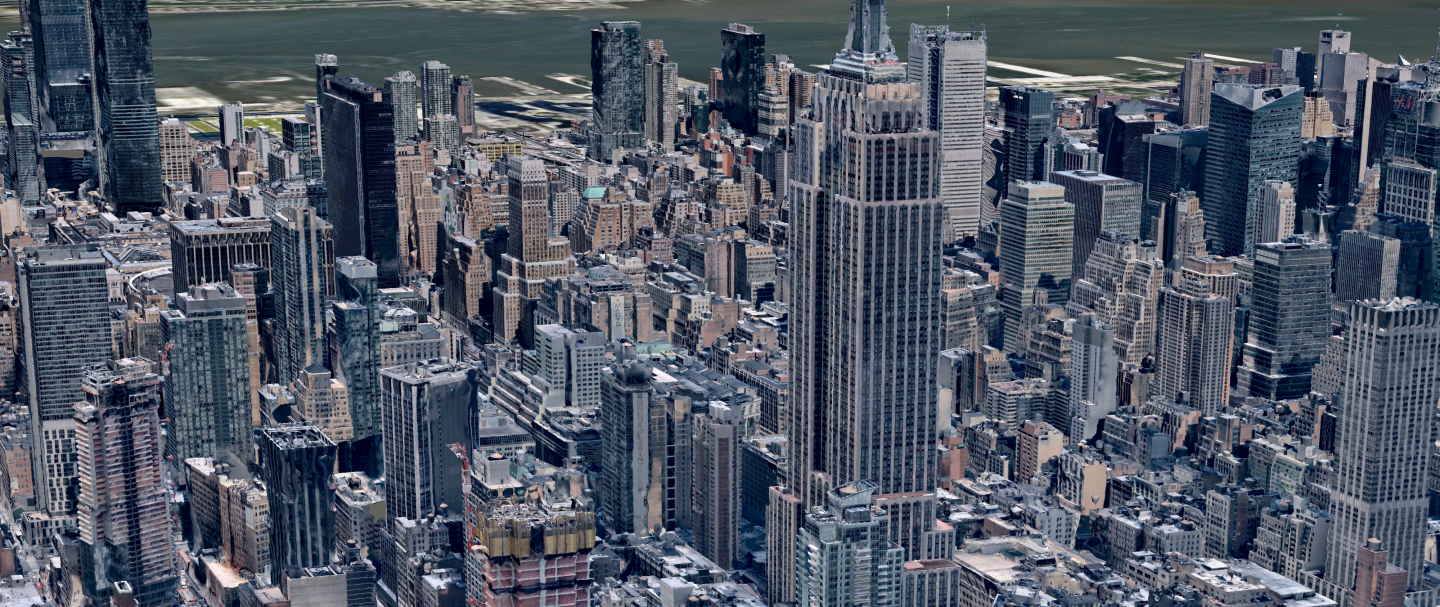
Imagine being able to fly over any of 12 urban areas in Australia (or nearly 80 cities in the US) and see the built environment below you in high resolution detail. Nearmap 3D lets you take that flight, but then — and here’s where it gets interesting — use photo-realistic 3D models to take measurements, line up a bird’s-eye view, approach a site from any angle, and generally scope out any area of interest with the benefit of real-world context.
Distances along borders, building heights, distances between building corners and nearby features: not only is the level of detail consistently high resolution, but the 3D models are useful in hugely practical and cost-saving ways. With no need to visit sites on spec, and many fewer requirements to put boots on the ground, the savings are immediate.
Construction managers, engineers, urban planners, and consultants from all verticals have long known about the power inherent in a highly detailed 3D model of an urban area. But until now, the cost of acquiring this data was astronomically high and took many weeks to source. With Nearmap 3D, the information you need is streamed online, letting you explore the project environment without delays.
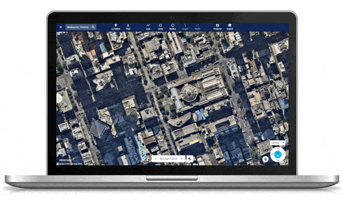
Benefiting from the unique imagery-as-a-service model Nearmap pioneered with 2D, 3D data can begin to add value to your workflows without any impediments. For business, or for government agencies, the benefits of Nearmap are changing the way projects are envisaged and realised, saving hundreds of hours on truck rolls and difficult in-person surveys. Existing and in-progress assets can be assessed and monitored with regularly-updated 3D data. In MapBrowser, an intuitive web app, you can switch between 2D and 3D base maps with a single click, and then pan, zoom, rotate, measure distances and pitch, and export data as you need it.
Nearmap 3D takes the friction out of working with 3D, and proves its ROI in a range of scenarios, from small commercial or residential building projects, right up to large-scale urban infrastructure projects for government and enterprise. The on-demand, cloud-based services are effective across industries, empowering organisations to:
- Respond to tenders with more accurate figures and realistic projections.
- Capture terrain across urban greenfield and brownfield sites.
- Stimulate planning conversations between stakeholders and interested parties.
- Identify vulnerabilities to proactively prevent public safety issues.
- Collate specialist information such as viewshed analysis, solar irradiance output, and environmental impact predictions.
From virtual site inspection, Nearmap takes you much further down the path towards project realisation: accusations of eye candy (albeit very smart eye candy) can be placed aside. Exploring an area in 3D is as simple as logging in, so even companies with no previous 3D experience get off to a flying start without specialist software. You can take vital measurements in the web app, and quickly and easily export data for use in third-party GIS and CAD software platforms (data is available as point cloud, textured mesh, DSM, or true ortho).
Source: Nearmap
Data is available going back to 2017, so you can explore a site of interest as it appeared in previous surveys. Nearmap’s custom-built camera systems capture and regularly update detailed 3D views over a huge footprint (23,000 km2 in Australia, 99,000 mi2 in the US), empowering businesses to monitor projects as they evolve over time.
Rich 3D data gets work underway with the right contextual insights, especially for companies that have balked previously at the cost of bespoke 3D surveying. And, the time it takes to acquire geospatial data drops from weeks or months of waiting for a physical hard drive delivery, to just a few minutes or hours for a download.
In the 12 covered urban areas in Australia, there’s simply no better way to remotely visualise and evaluate a project environment. Nearmap 3D lets organisations of any size explore opportunities and choices in depth, monitor progress, and do smarter business with high-res 3D imagery, at significantly lower cost and with far greater ease than before.
To learn more about this disruptive cloud-based technology and the rest of the Nearmap geospatial content library, click here.
READ MORE
- Ethical AI: The renewed importance of safeguarding data and customer privacy in Generative AI applications
- How Japan balances AI-driven opportunities with cybersecurity needs
- Deploying SASE: Benchmarking your approach
- Insurance everywhere all at once: the digital transformation of the APAC insurance industry
- Google parent Alphabet eyes HubSpot: A potential acquisition shaping the future of CRM