(Source – Nestle)
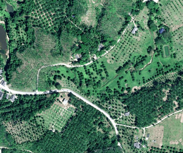
How Nestlé is using Pléiades Neo Satellite Imagery in its reforestation
When it comes to monitoring deforestation, reforestation, or any other natural events on the planet, satellite imagery can be a powerful tool for providing accurate information. With advancements in remote sensing technology, it is now possible to detect changes in forest cover and quantify deforestation rates using satellite imagery.
Satellite imagery can also be used to monitor deforestation in real time, enabling rapid response to illegal logging activities or other forms of forest degradation. For example, by analyzing high-resolution imagery, it is possible to identify areas where logging roads have been constructed, providing evidence of illegal logging activity.
Moreover, satellite imagery can also be used to estimate carbon emissions from deforestation, which can help inform climate change mitigation efforts. Forests play a crucial role in regulating the Earth’s climate by removing carbon dioxide from the atmosphere, and deforestation is a significant contributor to global greenhouse gas emissions.
The same technology can also be used for reforestation. Just as in deforestation, satellite imagery can provide valuable data for forest management and planning. By analyzing historical trends and predicting future changes in forest cover, policymakers can make informed decisions about land-use policies, conservation strategies, and sustainable development initiatives.
As such, Nestlé will be using the very high-resolution images from this cutting-edge technology to help ensure that the trees it has planted in sourcing regions continue to thrive over the long term. This approach will help Nestlé demonstrate the amount of carbon it is removing from the atmosphere through its Global Reforestation Program, a key pillar of its 2050 net zero emissions ambition.
According to Magdi Batato, Nestlé’s Executive Vice-President and Head of Operations, forests are often called Nature Based Solutions because it is a solution to help reduce emissions.
“Growing trees close to our sourcing locations is an essential part of our climate roadmap alongside decarbonizing our operations and supply chain. Through our Global Reforestation Program, we aim to plant and grow 200 million trees in our supply chains and sourcing landscapes by 2030. Our goal is to remove 2 million tonnes of CO2e through these projects,” commented Batato.
Nestlé will first apply the technology in the Ranong and Chumphon provinces of Southern Thailand, where a reforestation project has been ongoing since last year. Pléiades Neo satellites will monitor more than 150 000 shade trees in farms from where Nestlé sources its coffee, over a 20 year period. Shade trees help prevent coffee’s over-exposure to the sun, and increase yield and productivity in the long term, while also removing carbon from the atmosphere. Based on this experience, Nestlé will determine whether to expand the approach to other locations around the world.
Satellite imagery with Pléiades Neo satellites
Pléiades Neo satellites are a series of high-resolution Earth observation satellites developed by Airbus Defence and Space, a division of Airbus Group. The Pléiades Neo constellation consists of four identical satellites equipped with state-of-the-art sensors and imaging capabilities.
Designed to provide highly detailed and accurate images of the Earth’s surface, with a spatial resolution of up to 30cm, Pléiades Neo satellites can capture images of objects and features as small as a car or a person from space. The satellites are also equipped with advanced spectral capabilities, allowing them to capture images across a wide range of wavelengths. This enables the satellites to produce highly detailed and accurate images of natural and man-made features, including urban areas, vegetation, water bodies, and geological formations.
“Monitoring natural and intentional reforestation has now become as important as monitoring deforestation to restore natural carbon sinks and ensure sustainability. Pléiades Neo, with its 30 cm resolution, highest acquisition capacity and rich spectral configuration, is perfectly suited to follow replanting projects over large and remote areas,” explained Karen Florschütz, Airbus Executive Vice-President and Head of Connected Intelligence
Florschütz added that the cooperation with Nestlé will enable them to keep pioneering the development of innovative solutions to address climate change.
Nestlé has been using the Airbus and Earthworm Starling solution since 2016 to check for the risk of deforestation near its sourcing locations. With Pléiades Neo, the company is upscaling the monitoring service, applying a similar approach to the restoration and regeneration of landscapes.
READ MORE
- Strategies for Democratizing GenAI
- The criticality of endpoint management in cybersecurity and operations
- Ethical AI: The renewed importance of safeguarding data and customer privacy in Generative AI applications
- How Japan balances AI-driven opportunities with cybersecurity needs
- Deploying SASE: Benchmarking your approach


